Oceanic Manta Ray Surveys and Tagging with Manta Watch New Zealand
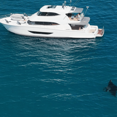
DISCOVERY Yacht Saluté
Hauraki Gulf, New Zealand
January 3 - 5, 2024
Leadership
Research Team
- Lydia Green
- Dr. Mark Erdmann, Ph.D
Project Overview
Despite being fully protected in New Zealand waters since 2011, under the Wildlife Act, the biggest threat to Aotearoa's oceanic manta rays is the lack of data. We simply don't know enough about this lesser known population to provide adequate protection or establish long term conservation management. To inform change, vital data relating to population dynamics, behaviour and habitat need to be collected through underwater video / images, aerial drone and satellite tag deployments.
Duration of Project
Ongoing
Expedition Summary
During January 3rd - 5th, 2024, The International SeaKeepers Society facilitated a 3 day expedition aboard DY Saluté. The expedition included conducting oceanic manta ray surveys, photographic images for identifying individual manta rays and deployment of satellite tags. The trip focused its efforts mainly off Great Barrier Island in the Hauraki Gulf starting from Port Fitzroy traveling south along the west coast down to Tryphena Bay. We were able to survey over 155 nautical miles in over 25.5 hours. We spotted 22 mantas, got 13 ventral (belly) IDs, and 19 dorsal (head) ID's and deployed 2 satellite tags. This data will help the Manta Watch NZ team determine local hotspots, New Zealand manta population size, where they breed, and how far they travel. This will enable scientists to assess the types of threats these animals and the wider population are exposed to and importantly how best to protect them.
Application
By using the height of DY Saluté to our advantage we started our surveys by keeping an eye on the water for any disturbances that were conducive to manta feeding behavior. Once a manta was spotted we deployed the drone to observe the mantas behavior, identify the gender, and get a dorsal and ventral ID. If we were unable to get an ID using the drone we would then jump in the water with underwater camera gear to get a positive ID. Every manta ray has a unique pattern of spots on its ventral surface or belly, that remain unchanged throughout that individual’s lifetime. The unique nature of these spots is incredibly helpful for manta scientists, enabling individual mantas to be identified just by photographing their belly’s. For deployment of the satellite tags Dr. Mark Erdmann uses an underwater scooter to help keep up with the sometimes fast-moving mantas, a speargun to deploy the tag, and a GoPro to get ID footage. A drone is kept over the manta which makes it helpful for Mark to keep up with the mantas movements, this is also used to do a wellness check of the manta after a tag is deployed to watch behavior and reaction to the tag.
Location
Hauraki Gulf, New Zealand


You must be logged in to post a comment.