Miami, FL – June 8, 2025 – In a bold leap toward mapping Earth’s final frontier, the seafloor, The International SeaKeepers Society (SeaKeepers), a global non-profit organization, is proud to support a historic advancement in this effort. As part of the global Nippon Foundation-GEBCO Seabed 2030 Project, SeaKeepers has been mobilizing private yachts through its DISCOVERY Fleet since 2021 to collect vital seafloor data. Since 2017, both the International Hydrographic Organization and the Seabed 2030 Project have worked to encourage citizen scientists around the world to join the important cause of mapping the seafloor, and the impact is clear. In U.S. waters alone, there has been an incredible increase in coastal mapping efforts since the launch of this project. Now, thanks to this citizen-powered effort, the National Oceanic and Atmospheric Administration (NOAA) has achieved a milestone never before accomplished at this scale.
Learn More — International Hydrographic Organization
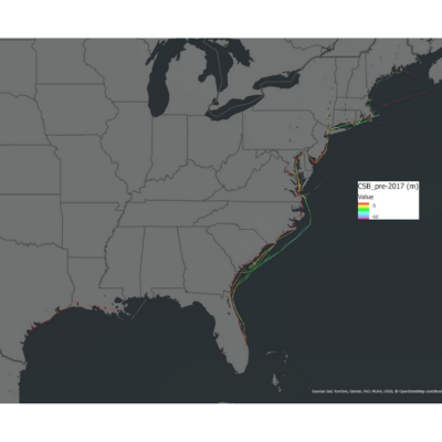
Caption: Before 2017, little CSB data had been collected along the U.S. Gulf and Atlantic coasts.
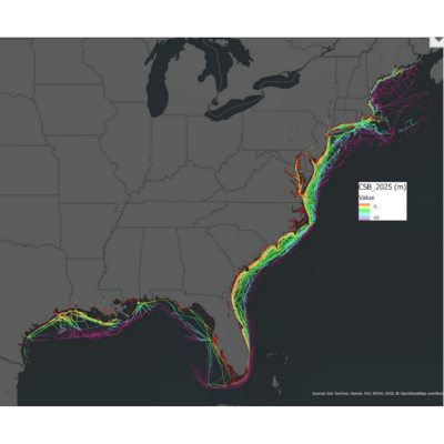
Caption: Since the launch of Seabed 2030 in 2017, there has been a significant increase in available CSB data.
For the first time ever, NOAA has processed the entire body of publicly-contributed crowdsourced bathymetric (CSB) data collected along the Gulf and Atlantic coasts of the United States, totaling over 315 million individual depth observations (accessible via the NOAA-hosted IHO Data Centre for Digital Bathymetry Data Viewer). These data were scraped from the publicly available Data Center for Digital Bathymetry under the International Hydrographic Organization. Of these, SeaKeepers DISCOVERY Vessels contributed more than 4 million data points, thanks to the hard work of 11 DISCOVERY vessels within our fleet. These data points, gathered by everyday vessels navigating familiar waters have allowed researchers to look at poorly described and/or ever-changing seafloor features in a new light.
Learn More — NOAA-hosted IHO Data Centre for Digital Bathymetry Data Viewer
Haley Davis, SeaKeepers’ Data Scientist:
“This is a revolution in how we understand our oceans. What used to rely solely on dedicated and costly expeditions with specialized ships can now be accelerated with support from recreational boaters. Through our DISCOVERY Fleet, SeaKeepers is helping scientists see parts of the seafloor that were previously unmapped, as well as documenting important changes in seafloor shape over time. In this way, recreational boats are contributing not only to exploration, but also to maintaining safe and navigable waterways for all who enjoy spending time on the water.”
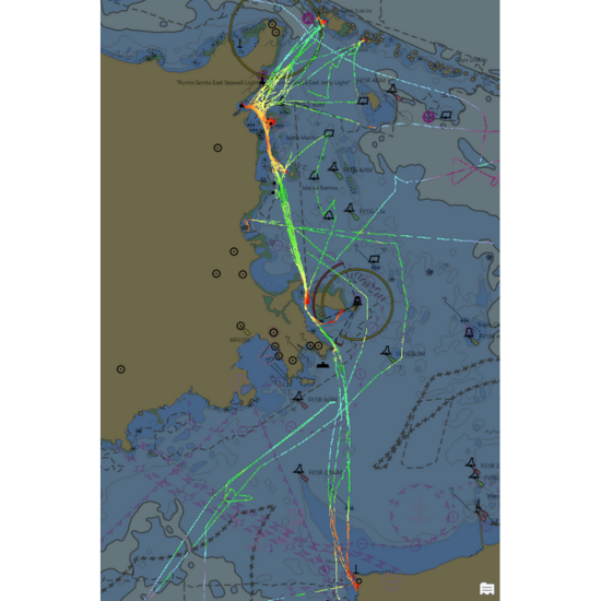
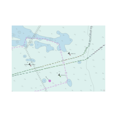
Caption: This nautical chart highlights CSB data collected in part by SeaKeepers DISCOVERY Vessels. The information here will help characterize the seafloor shape between Puerto Rico, Culebra, and Vieques.
In many locations across South Florida and Puerto Rico, SeaKeepers DISCOVERY Vessels are providing data that sheds light on areas where the seafloor has historically been poorly understood or often changing, allowing hydrographers to allocate resources to official surveying or re-surveying. A great example of this can be found in the data collected by DISCOVERY Vessel “Relaz” which has contributed important data to the characterization of the seafloor region between Puerto Rico, Culebra, and Vieques, according to NOAA Physical Scientist researcher Anthony Klemm.
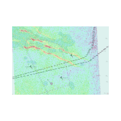
Caption: The nautical chart displays official depth estimates of 11 to 13 meters in the white areas. The two diagonal lines represent CSB tracks, with red segments indicating significantly shallower depths (approx. 5 meters) demonstrating notable discrepancies between observed data and charted depths.
Caption: This updated map includes an overlay of satellite derived bathymetry which shows that – in agreement with the CSB indicators – the shallow bank (originally outlined in blue) has shifted to the right (now shown in red). This change highlights the potential risk of grounding and underscores the importance of re-surveying efforts.
Using advanced data-processing techniques, correcting for tides, accounting for vessel draft calibrating for equipment configurations, and filtering outliers with automated models, NOAA has turned scattered soundings into structured, actionable information. Each vessel transit has been parsed and annotated with metadata, which lays the groundwork for precise integration into NOAA’s BlueTopo, the official national bathymetry model.
Learn More — NOAA’s BlueTopo
With this publicly available information, NOAA analysts and hydrographers are looking toward next steps by creating tools that highlight discrepancies between official nautical charts and publicly available CSB data. These internal tools are helping to inform the way hydrographic reviews and re-surveys are commissioned. Eventually, many are hoping to find a way to integrate this information into official nautical charts. While these changes may take time, NOAA, via the IHO, allows the public to discover and access all of this data to be used for a myriad of purposes through this valuable database.
Haley Davis, SeaKeepers’ Data Scientist:
“This is not just about filling gaps. It’s about documenting the changing nature of our Ocean. We’re uncovering seafloor features that have moved or shifted with storm activity and using these new and valuable data to improve the charts mariners rely on every day.”
Seabed 2030, a joint initiative between The Nippon Foundation and GEBCO, aims to map 100% of the world’s ocean floor by 2030. With only about 25% of the seabed mapped to modern standards, contributions from citizen science are more critical than ever.
SeaKeepers is calling on more vessel owners to join the movement by applying to join the DISCOVERY Program. Every depth reading collected helps improve global ocean safety, environmental protection, and scientific discovery.
Learn More — DISCOVERY Program
ABOUT THE INTERNATIONAL SEAKEEPERS SOCIETY
The International SeaKeepers Society is a not-for-profit 501(c)(3) organization that facilitates oceanographic research, conservation, and education through direct involvement with the yachting community. Providing educational resources and hands-on marine science experiences to students is the primary focus for ensuring the wellbeing of our planet. SeaKeepers enables the yachting community to take full advantage of their unique potential to advance marine sciences and raise awareness about global ocean issues.
Founded in Monaco in 1998, The International SeaKeepers Society has been supporting ocean conservation through direct involvement with the yachting community for more than twenty-five years. What started as a data collection program aboard select luxury yachts, has evolved to engage thousands of participants annually with at-sea and coastal programming. Today SeaKeepers’ mission is focused on the DISCOVERY Yacht Program which is comprised of Scientist-Led Expeditions, Citizen Science, Educational Outreach, and Community Engagement.
As a catalyst working with governments, scientists, institutions, and other marine organizations to further its mission, SeaKeepers supports sensible, achievable marine protection and restoration. Activities take place globally through the efforts of headquarters based in the United States with offices located on the east and west coast, and international representation in Singapore, the United Kingdom, and the South Pacific.
VISIT WEBSITE — SEAKEEPERS.ORG